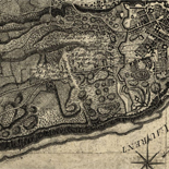
![[Map of Madison County, Va.].](https://cybercemetery.unt.edu/archive/oilspill/20130108005548im_/http://www.loc.gov/collections/static/hotchkiss-maps/images/cwh00046.jpg)
![Amérique septentrion.lle [i.e. septentrionale] : composée, corigée, et augmētée, sur les iournaux, mémoires, et observations les plus justes qui en ón'́etes.tes en l'année 1685 & 1686, par plusieurs particuliés](https://cybercemetery.unt.edu/archive/oilspill/20130108005548im_/http://www.loc.gov/collections/static/discovery-and-exploration/images/ct000667.jpg)

![[December 21, 1944], HQ Twelfth Army Group situation map.](https://cybercemetery.unt.edu/archive/oilspill/20130108005548im_/http://www.loc.gov/collections/static/world-war-ii-maps-military-situation-maps-from-1944-to-1945/images/ict21200.jpg)


![[December 16, 1944], HQ Twelfth Army Group situation map.](https://cybercemetery.unt.edu/archive/oilspill/20130108005548im_/http://www.loc.gov/collections/static/world-war-ii-maps-military-situation-maps-from-1944-to-1945/images/ict21195.jpg)
![[January 18, 1945], HQ Twelfth Army Group situation map.](https://cybercemetery.unt.edu/archive/oilspill/20130108005548im_/http://www.loc.gov/collections/static/world-war-ii-maps-military-situation-maps-from-1944-to-1945/images/ict21228.jpg)
Results
Refined by:
Original Format: Map-

A map of the provinces of New-York and New-Yersey, with a part of Pennsylvania and the Province of Quebec.
Scale ca. 1:1,040,000.
Contributor: Sauthier, Claude Joseph Site: American Memory-cultural - Main Catalog Original Format: Map Date: 1777 View catalog record -

Sanborn Fire Insurance Map from Belton, Bell County, Texas.
6 Sheet(s). Oct 1907.
Site: American Memory-cultural Original Format: Map Date: 1907-01-01 -

Battle of Missionary Ridge or Chickamauga, Tenn.
Color coding indicates the location of Union and Confederate forces.
Contributor: Sneden, Robert Knox Site: American Memory-cultural Original Format: Map Date: 1861 -

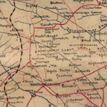
Ed. H. Radcliffe's (Frankford, Pa.) business map of Bristol, Bordentown, Burlington, and Mount Holly.
General city/borough street maps.
Contributor: Radcliffe, Edward H. Site: American Memory-cultural - Main Catalog Original Format: Map Date: 1870 View catalog record -

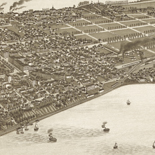
Honey Grove, Tex. Fannin County 1886.
Perspective map not drawn to scale.
Contributor: Wellge, H. Site: American Memory-cultural - Main Catalog Original Format: Map Date: 1886 View catalog record -

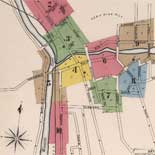
Lewisburgh.
Perspective map not drawn to scale.
Contributor: O.H. Bailey & Co Site: American Memory-cultural - Main Catalog Original Format: Map Date: 1884 View catalog record -

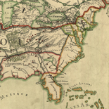
Algeria.
Relief shown by shading.
Contributor: United States. Central Intelligence Agency Site: American Memory-cultural - Main Catalog Original Format: Map Date: 2001 View catalog record -

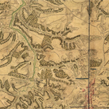
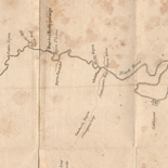
[Map of the Etowah River from Rome to Cartersville, Georgia].
Shows fords, bridges, and ferries across the Etowah River spanning southeastern Floyd County and southwestern Bartow County, Georgia. Fortifications shown at Caldwell Ford, Bartow County.
Site: American Memory-cultural - Main Catalog Original Format: Map Date: 1864 View catalog record -

Jermyn, Lackawanna County, Pa.
Perspective map not drawn to scale.
Contributor: Fowler, T. M. Site: American Memory-cultural - Main Catalog Original Format: Map Date: 1889 View catalog record -

Map of Clay County, Texas /
Shows landownership.
Contributor: Texas. General Land Office Site: American Memory-cultural - Main Catalog Original Format: Map Date: 1880 View catalog record -

Map of the battle field of Carnifex Ferry, Gauley River, West Va., Sept. 10th 1861 : United States forces commanded by Brig. Gen. W.S. Rosecrans.
"Copied from a Map accompanying the Report of Gen. Rosecrans."
Contributor: United States. Army. Corps of Engineers Site: American Memory-cultural Original Format: Map Date: 1876 -

Chad : [administrative divisions].
Available also through the Library of Congress Web site as a raster image.
Contributor: United States. Central Intelligence Agency Site: American Memory-cultural - Main Catalog Original Format: Map Date: 1977 View catalog record -

Plano de las Tortugas situado su sentro en la latitud N. 24p0s grs. 37 ms.
Depths shown by soundings.
Site: American Memory-cultural - Main Catalog Original Format: Map Date: 1700 View catalog record -

Map of Clinton County, Ohio /
"Entered according to Act of Congress in the year 1858 by HF Walling in the clerks office of the District Court of the United States for the Southern District of New York."
Contributor: Walling, Henry Francis Site: American Memory-cultural Original Format: Map Date: 1859 -

Map of Harrisburg City, Dauphin Co. Pa. /
City street map showing ward boundaries, ward names, and principal buildings.
Contributor: Boyd, William Henry Site: American Memory-cultural - Main Catalog Original Format: Map Date: 1893 View catalog record -

The country twenty-five miles round London : planned from a scale of one mile to an inch /
Relief shown by hachures.
Contributor: Faden, William Site: American Memory-cultural - Main Catalog Original Format: Map Date: 1790 View catalog record -

Sanborn Fire Insurance Map from Advance, Boone County, Indiana.
1 Sheet(s). Jan 1919.
Site: American Memory-cultural Original Format: Map Date: 1919 -

[August 26, 1944], HQ Twelfth Army Group situation map.
Available also through the Library of Congress web site as a raster image.
Contributor: Allied Forces. Army Group, 12th. Engineer Section Site: American Memory-cultural - Main Catalog Original Format: Map Date: 1944-08-26 View catalog record -

Map showing the line of the Toledo, Wabash, & Western Railway Company and its connections.
Scale ca. 1:3,750,000.
Contributor: G.W. & C.B. Colton & Co Site: American Memory-cultural - Main Catalog Original Format: Map Date: 1873 View catalog record -

Guangxi quan tu /
Scale ca. 1:1,000,000.
Contributor: Hubei Sheng (China). Guan shu ju Site: American Memory-cultural - Main Catalog Original Format: Map Date: 1864 View catalog record