
Related Resources at the Library
July 11, 1861
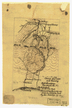
![[Map of the Rich Mountain battlefield, W. Va. July 11-12, 1861]](https://cybercemetery.unt.edu/archive/oilspill/20130119180052im_/http://www.loc.gov/rr/geogmap/placesinhistory/images/cwh00071.gif)
[Map of the Rich Mountain battlefield, W. Va. July 11-12, 1861]
Camp Garnett and vicinity, Rich Mountain, Randolph Co., Va.
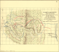
War of the Rebellion: Pl. II, Map 6 - Rich Mountain, Camp Garnett
At the conclusion of the Civil War, the U.S. War Department published numerous detailed battlefield maps and atlases to document significant military engagements such as those at Antietam, Manassas, Gettysburg, and Atlanta, to name a few. The premier cartographic work of the postwar years, however, is the U.S. War Department's Atlas to Accompany the Official Records of the Union and Confederate Armies (LC Civil War Maps no. 99). Initially issued in 37 parts between 1891 and 1895, it includes 178 plates and constitutes the most detailed atlas yet published on the Civil War. The maps present an especially well-balanced cartographic record of the war because both Union and Confederate sources were used in their compilation. Confederate topographic engineer Jedediah Hotchkiss, for example, supplied the editors with 123 maps for this atlas.
Two of the maps Hotchkiss supplied for those compiling the atlas relate to skirmishes near Rich Mountain, in Randolph County, near the western border of present day West Virginia. In the early summer of 1861, both Union and Confederate troops increasingly engaged in skirmishes as both sides continued to test each other’s will. By July, 1861, Union troops led by Mclellan, had entered western Virginia and could potentially threaten the Baltimore and Ohio Railroad and the Virginia Central Railroad, both of which were vital Confederate supply lines.
On July 11, McClellan successfully attacked Camp Garnett near Rich Mountain and followed up the success with another victorious skirmish at Corrick’s Ford. These military successes brought McClellan to the attention of Union military leaders and were instrumental in McClellan’s eventual appointment as overall Union commander.
Map Citations
[Map of the Rich Mountain battlefield, W. Va. July 11-12, 1861]. 1 ms. map : col. ; 21 x 14 cm.
Catalog record: http://lccn.loc.gov/2003629668
Hotchkiss, Jedediah. Camp Garnett and vicinity, Rich Mountain, Randolph Co., Va. / by order of Lt. Col. J.M. Heck, commanding post, July 1861; by Jed. Hotchkiss, Top. Eng. 1 map : col. ms. ; 21 x 13 cm.
Catalog record: http://lccn.loc.gov/2002627474
United States War Department. Atlas to accompany the official records of the Union and Confederate armies. (3 v. CLXXV (i.e. 178) fold. pl. (incl. illus., maps, plans) 48 x 40 cm.): Washington, Govt. Print. Off., 1891-95. Plate II, Map 6.
Catalog record: http://lccn.loc.gov/03003452