Jump to:
- Northern Publishers
- Southern Publishers
- British Publishers
- Propoganda Maps
- Battlefield Maps
- Panoramic Maps
- City Plans
- Maps in Newspapers & Journals
- References
Commercial Mapping
Throughout the American Civil War, commercial publishers in the North and to a lesser extent in the South produced countless maps for an eagerly awaiting public in need of up-to-date geographical information. Few families were without someone in the armed forces serving in a little-known place in the American South. Maps, therefore, were not only important sources of information, but also satisfied the patriotic impulses of the populace. Publishers in New York, Philadelphia, Washington, and Boston quickly became aware of this profitable market and began to issue maps in quantities undreamed of before the war.
Northern Publishers
One of the earliest maps, copyrighted by M. H. Traubel of Philadelphia less than a month after the bombardment of Fort Sumter on April 12, 1861, is entitled "Pocket Map of the Probable Theatre of the War." The compiler of the map, civil engineer G. A. Aschbach, accurately anticipated that the principal seat of war in the East would be Virginia, Maryland, and Pennsylvania. To assist the map user, Aschbach underlined camps and forts in red and prominent places in blue (LC Civil War Maps no. 1).
Many of the early maps were little more than general maps depicting railroads, rivers, state boundaries, cities and towns, and perhaps a few well-known forts. "Lloyd's Map of the Southern States" for example, produced and sold by James T. Lloyd, publisher of Lloyd's American Railroad Weekly, was very popular and was issued in each of the first three years of the war. Although Lloyd included little specific information about the war on his map, he issued it after July 12, 1861, with an extensive "gazetteer of the Southern States" printed on the verso.1

![]()
![]() Pocket Map of the Probable Theatre of the War.
Pocket Map of the Probable Theatre of the War.
Lloyd's maps are especially interesting today for the informative advertisements and testimonials that the publisher unabashedly included on them. One advertisement, for example, called attention to Lloyd's "$100,000 Topographical Map of the State of Virginia," priced at 25 cents a copy, and about which the publisher noted, "we intend to sell 3,000,000 copies of this great map" (LC Civil War Maps no. 14.25).
Although it is doubtful that Lloyd sold so many copies, his map of Virginia was indeed popular with the public with editions appearing in 1861, 1862, and 1863. Lloyd based his first edition on the Wood-Böÿe nine-sheet map of Virginia initially published in 1826 (mistakenly cited by Lloyd as 1828) and revised in 1859 by Ludwig von Buchholtz. To enhance his map over his competitors, Lloyd called his the "official map" and included a note on the 1861 edition that "This is the only map used to plan campaigns in Virginia by Gen. Scott." (LC Civil War Maps no. 450).
The 1862 edition announced that it had been "corrected from surveys made by Capt. W. Angelo Powell, of the U.S. Topographical Engineers." Since the aged Gen. Winfield Scott had been forced into retirement by then, Lloyd now noted that "This is the only map used to plan campaigns in Virginia by Gen. McClellan." (LC Civil War Maps no. 465.1).
During the war, James Lloyd carried on an acrimonious dispute with another New York publisher, H. H. Lloyd and Company. On his map of the Mississippi River issued in 1863, James Lloyd cautioned the public "against another `Lloyd' by which name he hopes to deceive the public with spurious `Lloyd Maps.' This man's maps are engraved coarsely on wood and very erroneous. He follows us with an imitation of every map we issue." H. H. Lloyd's map of the Mississippi River, engraved on wood by Waters and Company (LC Civil War Maps no. 37.2), is indeed inferior in appearance and content to James Lloyd's very detailed, nicely lithographed map (LC Civil War Maps no. 41). It is difficult to determine, however, whether or not the former purposely traded on the name of the latter.
While it is true that H. H. Lloyd's maps are somewhat coarse, they are good examples of wood-engraved maps, and they are generally clear and easy to read. The 1865 edition of his "New Military Map of the Border & Southern States," for example, emphasizes battlefields by red underlining, and strategic places by red dots. Furthermore, it effectively delineates in red the "territory held by Rebels April 1st, 1865," in yellow, the "territory gained from Rebels since January 1st, 1862," and in blue, "Sherman's march from Chattanooga" (LC Civil War Maps no. 71).
To enhance sales, some publishers went to great lengths to make their maps as distinctive from those of their competitors as possible. For instance, Prang and Company of Boston conceived the idea of publishing a "War Telegram Marking Map" on which one could follow the events of the war. This popular map, issued in at least six editions, was published on a large scale to permit the marking of "change of position of the Union forces in red pencil and the rebel forces in blue on the receipt of every telegram from the seat of war." The map was accompanied by colored pencils which the publisher noted "should be used with a light hand to enable obliterating the marks with the aid of a little soft bread, if found necessary. These peculiarities combined with extreme cheapness will make this map a welcome companion to every person interested in the pending struggle of our nation." (LC Civil War Maps no. 465.75).
Prang's map, primarily designed for the use of the citizen back home, included an advertisement for "Agents wanted to sell this map in all parts of the country." Some Northern publishers also aimed their maps at the lucrative market comprising the officers and enlisted men serving in the Union armed forces. Boston publisher John H. Bufford's map of Georgia and South Carolina, entitled "Genl. Sherman's Campaign War Map," and his map of the environs of Richmond, Virginia, entitled "Genl. Grant's Campaign War Map," both carried notes that "Agents wanted in all the camps and throughout the loyal states to sell this map, pictures & photographs of every description." (LC Civil War Maps nos. 124 and 623). Bufford's maps are particularly interesting because of their use of a letter-number grid reference system, described by the publisher as follows:
The horizontal and upright lines [of the map grid] represent five miles square. By referring to the number on the left and to the letter on the base, any point may be found to show the locality of the Union armies. By this method those in the army are enabled to inform their friends of the movements of their companies and their location and will also serve as a journal to each soldier.
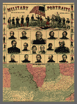
As another means of maximizing sales, publishers sometimes combined various kinds of illustrative data. In 1861, for example, H. H. Lloyd published a brightly colored wood engraving featuring "Military Portraits, Map of the Seat of War, Uniforms, Arms, &c." Here the map of the "Western Border Lands" occupied only a third of the printed sheet and definitely was of secondary importance to the portraits of the war heroes (LC Civil War Maps no.12.7).
Other publishers depended on bold titles emblazoned across the sheet to catch the citizen's attention and hopefully to sell the map. The title to the W. H. Forbes and Company's unimaginative map of Central Virginia certainly "sells" the map. It reads in part: "Theater of the War: A Complete Map of the Battle Ground of Hooker's Army!!" (LC Civil War Maps no. 479.5).
The New York and Washington publisher Charles Magnus sold his popular map of "One Hundred & Fifty Miles Around Richmond" separately and as part of a "Half Dollar Portfolio." Included with the map in this "Glorious Union Packet," as the publisher called it, was a Mirror of Events [i.e., list of battles], 2 illustrated Notesheets, 1 Song Notesheet, 3 illustrated Envelopes, 6 Portraits of Army and Navy Officers, 4 plain Notesheets, 4 plain Envelopes, Penholder, [and] Pen and Lead-pencil" (LC Civil War Maps no. 632.4).
![]()
![]() Western Border States
Western Border States
Southern Publishers
Compared to those in the North, publishers in the South produced few maps for the general public, and those that did appear were issued in small numbers. Printing presses and paper, as well as lithographers and wood engravers, were in short supply. The few maps published for sale to the public were invariably simple in construction, relatively small in size, and usually devoid of color. The Confederate imprint, "Map of the Seat of War in Virginia," is representative. Lithographed and published by Blanton Duncan in Columbia, South Carolina, it is dated December 1, 1862, and measures only 37 by 24 cm. (LC Civil War Maps no. 457).
British Publishers
The broad interest among the British in the American Civil War is evidenced by the number of maps produced by some of the major contemporary map publishers of Great Britian--James Wyld, George Philip, Edward Stanford, Bacon and Company in London, and John Bartholomew in Edinburgh. The leading English publisher and seller of maps of the American Civil War was Bacon and Company. By 1862, this firm had published a series of six maps that were known collectively as the "Shilling War Maps." In an advertisement, the firm described the maps as being a "complete series, just published, compiled from authentic sources, and corrected to the present time--showing the railways, forts, and fortifications, population, area, &c, and designating in three colors the boundaries of the Federal, Confederate, and Border Slave States."2 An example of one of the shilling war maps is "Bacon's Military Map of the United States Shewing the Forts & Fortifications" (LC Civil War Maps no.24). Published in August 1862, it delineates by color the "Free or Non-slaveholding States," the "Border Slave States," and the "Seceded or Confederate States." In addition to publishing maps, Bacon also served as agent in Britain for "Colton's Maps of America, and Complete Series of War Maps." Joseph H. Colton was described by the firm as being for "30 years the largest American Map Publisher."3
Propaganda Maps
Although propaganda maps are better known from their use during World Wars I and II, an occasional map of this type was published during the Civil War. Such works are designed to have a maximum psychological impact on the user of the map. The commercial publisher J. B. Elliott of Cincinnati published a cartoon map in 1861 entitled "Scott's Great Snake" which pictorially illustrates Gen. Winfield Scott's plan to crush the South both economically and militarily. His plan called for a strong blockade of the Southern ports and a major offensive down the Mississippi River to divide the South. The press ridiculed this as the "Anaconda Plan," as shown on this map, but this general scheme contributed greatly to the Northern victory (LC Civil War Maps no.11).
Another propaganda map more subtle in appearance, but perhaps just as effective, was Edmund and George Blunt's "Sketch of the Atlantic and Gulf Coasts of the United States." The Blunts depicted the "loyal part" of the coast with a heavy (strong) line and the "rebel part" with a thin (weak) line. "This sketch was prepared to show at a glance," explains George Blunt, "the difference in extent of the coasts of the U. States occupied by the loyal men and rebels; its circulation it is believed will have the effect of counteracting the exertions of traitors at home as well as those abroad. Persons having correspondents in Europe would do well to send copies of this sketch to them for circulation" (LC Civil War Maps no. 25).

![]()
![]() Scott's Great Snake
Scott's Great Snake
Battlefield Maps
Countless large-scale maps of battlefields, sieges, and fortifications were produced by commercial firms. Maps of those places and events in the news, particularly those perceived to be victories, guaranteed the publisher a quick profit from a grateful public. To give authenticity to their products, publishers based their maps on "reliable" eyewitness accounts, including those of active participants. For example, the "Map of the Battlefield of Antietam," lithographed by the Philadelphia firm of Duval and Sons, was prepared by Lt. William H. Willcox, Topographical Officer and Additional Aide-de-camp on the staff of Brig. Gen. Abner Doubleday, commander of a Union Division at the Battle of Antietam (although better known today as the inventor of baseball). It is interesting to note that this particular copy is inscribed in longhand, "Obtained from Washington & presented to Gen. R. E. Lee by J. E. B. Stuart" (LC Civil War Maps no. 253).
To further expand on the information depicted cartographically, some compilers and publishers added descriptive text to their battle maps. Boston publisher George W. Tomlinson, for example, printed beside his "New Map of Port Hudson" (1863), a one-column "Sketch of Port Hudson and the surrounding batteries" (LC Civil War Maps no. 240). Theodore Ditterline went further, supplementing his unusually shaped oval map of the "Field of Gettysburg" with a 24-page pamphlet describing the battle in detail (LC Civil War Maps no. 331).
![Detail of [Portrait of Brig. Gen. Abner Doubleday, officer of the Federal Army (Maj. Gen. from Nov. 29, 1862)]](https://cybercemetery.unt.edu/archive/oilspill/20130116232454/http://memory.loc.gov/service/pnp/cwpb/04400/04466r.jpg)
![]()
![]() Detail of [Portrait of Brig. Gen. Abner Doubleday, officer of the Federal Army (Maj. Gen. from Nov. 29, 1862)]
Detail of [Portrait of Brig. Gen. Abner Doubleday, officer of the Federal Army (Maj. Gen. from Nov. 29, 1862)]
Panoramic Maps
Perhaps the finest and most attractive battle map produced during the war was John B. Bachelder's "Gettysburg Battle-Field" (LC Civil War Maps nos. 321-324). Bachelder, an experienced prewar maker of city views, copyrighted his stunning perspective drawing of the field of battle in 1863. In the opening sentence to the accompanying key, Bachelder invited the viewer of his panorama to "Imagine yourself in a balloon, two miles east of the town of Gettysburg, Pa." Not only was the map an artistic success, its accuracy was attested to by no less an authority than the commanding general of the Army of the Potomac at Gettysburg, George G. Meade. Reproduced in a facsimile below the map, Meade's handwritten endorsement reads, "I am perfectly satisfied with the accuracy with which the topography is delineated and the position of the troops laid down." The signatures of other field commanders attesting to the "accuracy of our respective commands" are also reproduced in the bottom margin.

![]()
![]() Detail of [Portrait of Maj. Gen. George G. Meade, officer of the Federal Army]
Detail of [Portrait of Maj. Gen. George G. Meade, officer of the Federal Army]
Bachelder subsequently became one of the directors of the Gettysburg Battlefield Memorial Association and Superintendent of Legends and Tablets. He was responsible for the compilation and publication in 1876 of a very detailed three-sheet map of the battlefield which still is widely used today (LC Civil War Maps no. 325). For his base map, Bachelder used the survey conducted in 1868 and 1869 under the direction of Gen. Gouverneur K. Warren, U.S. Army Corps of Engineers and revised in 1973 by P. M. Blake (LC Civil War Maps no. 353.5).
The panoramic map in fact became a popular and effective technique for conveying information about the Civil War. Early in 1861, the skillful artist and lithographer John Bachmann of New York City conceived the idea of producing a series of bird's-eye views of the likely theaters of war. These visually attractive panoramas were easily understood and perhaps more meaningful to a public largely unskilled in map reading. Between 1861 and 1862, Bachmann drew and lithographed at least eight panoramas of the seats of war in Virginia and Maryland, Richmond, North and South Carolina, Florida and part of Georgia, the confluence of the Ohio and Mississippi Rivers, Kentucky and Tennessee, the Gulf Coast in the vicinity of the Mississippi delta, and Texas and part of Mexico (LC Civil War Maps nos. 1.5-3, 23.5, 117.2, 304.5-304.6, 446.8 and 621).
The panoramic map or bird's-eye view also lent itself to colorful depictions of fortifications, hospitals, prisons, and military camps. Excellent representative examples of these are the Baltimore artist and lithographer Edward Sachse's bird's-eye view of Fortress Monroe, Virginia, published and sold in 1861 by Casimir Bohn of Washington, D.C., and Charles Magnus of New York City (LC Civil War Maps nos. 547 and 547.1); "Point Lookout, Md. View of Hammond Genl. Hospital & U.S. Genl. Depot for Prisoners of War," also lithographed by Edward Sachse & Company, and copyrighted in 1864 by George Everett (LC Civil War Maps no.257); and Albert Ruger's "Bird's eye view of Camp Chase, near Columbus, Ohio" (LC Civil War Maps no.318).
The commercial success of bird's-eye views contributed to the widespread adaptation of the technique after the war for the depiction of American and Canadian cities and towns.4 Albert Ruger, mentioned above, was the first successful postwar artist to produce urban panoramas.5 His earliest extant drawings were made during the war and are of military camps (LC Civil War Maps nos. 318, 319.5 and 660).

![]()
![]() Detail of [Portrait of Maj. Gen. Gouverneur K. Warren, officer of the Federal Army]
Detail of [Portrait of Maj. Gen. Gouverneur K. Warren, officer of the Federal Army]
City Plans
Commercial publishers also issued an occasional city plan, usually to depict seige or defensive positions. A fine example is civil engineer E. G. Arnold's well-executed map of Washington, D.C., showing the ring of fortifications built to defend the nation's capital from Confederate attack. Because of the sensitive information that Arnold's map contained, the Federal government suppressed its sale shortly after it was published (LC Civil War Maps nos. 674-674.1).
Maps in Newspapers and Journals
Another readily available, yet inexpensive source for maps were the major newspapers and pictorial journals of the day. Maps had occasionally appeared in journals or newspapers since the seventeenth century, but in North America it was not until the American Civil War that they were published with any regularity. At that time, all types of illustrations had reached a new level of popularity. One authority has noted that "Harper's, Leslie's and their lesser rival, the New York Illustrated News . . . employed twenty-seven 'special' or combat artists during the war, and also used the work of more than three hundred identified amateurs as well as of a great many photographers. All together, these three northern weeklies printed nearly six thousand war pictures." 6 Since no inventory or bibliography of maps in newspapers and journals has been compiled, it is not known if any of the combat artists and amateurs also supplied their publishers with sketch maps.
Most newspaper and journal illustrations were printed from woodcuts. This form of reproduction, albeit crude, was inexpensive, reasonably quick to execute, and the woodblocks could be inserted into pages of text and printed on newspaper presses without difficulty. A close-grained hardwood, usually boxwood, cut against the grain, was employed to make the wood engraving. Usually the blocks consisted of several parts tightly bolted together from the rear, a technique invented in England and pioneered in this country by Frank Leslie. After the image was drawn on the block, the parts were separated and distributed among several wood engravers to be worked on simultaneously. Once the carving was completed, place names cast in type metal from a mold (stereotype) were cemented into place, the parts bolted together again, and the whole retouched to insure uniformity. An electrotype metal copy of the woodcut was made and the illustration was ready for printing on the rotary press. The entire process required approximately two weeks to complete from the time the sketch was received by the publisher.
The public was enthralled by pictorial representations of the war, and pictures did much to shape their image and opinion of events and people in the news. Although sometimes lacking the timeliness and artistic merit found in many of the "on the spot" depictions from the battle fronts and military camps, maps nevertheless provided valuable information on the location of places in the news.
Included in the collections of the Library of Congress is a rare example of a woodblock that was used to print a panoramic map published in the March 22, 1862, edition of the New York Illustrated News. Entitled "Scene of the late naval fight and the environs of Fortress Monroe, and Norfolk and Suffolk, now threatened by General Burnside," it was printed from a 25 by 36 cm woodblock composed of 12 separate parts bolted together, each part measuring 13 by 6 cm. The woodblock is now imperfect, with the lower right and left corners missing and some of the individual parts beginning to separate due to age (LC Civil War Maps no. 558.7).
From the bombardment of Fort Sumter on April 12, 1861, to the end of the war, maps were occasionally used to illustrate major events or situations. On June 17, 1861, for example, the New York Herald published a timely map entitled "The Seat of War in Virginia" (LC Civil War Maps no. 451.3). This simple woodcut, published a little more than a month before the Union's disastrous defeat at the first Battle of Manassas, depicts strategic cities and towns, transportation routes, fortified positions, and the location and number of Confederate troops at several locations. The map noted, for example, that there were "15,000 troops at Manassas Junction and 15,000 more on the Manassas Gap Railroad" nearby. Executed by Waters and Son, Engravers, New York, it is typical of the maps that appeared throughout the war in newspapers and weekly journals. With minor variations the map was used again on July 27 by the New York Herald. This time, however, it served as the lead map in a special supplement of 34 maps entitled "War Maps and Diagrams" (LC Civil War Maps no.14.65).
The New-York Daily Tribune, not to be outdone by its rival, published "The Tribune War Maps" as a supplement to its daily paper issued on July 30, 1861 (LC Civil War Maps no. 6.2). This section of 17 maps was compiled and engraved on wood by the well-known New York map publisher, George Woolworth Colton. One of the maps in this section that contained some noteworthy strategic information is entitled "Baltimore and Its Points of Attack and Defence." The accompanying explanation notes that "The above drawing, which has been kindly furnished for the The Tribune by an officer of the United States Engineers, exhibits very clearly the points in Baltimore which might be held by military forces whether for purposes of attack or of occupation merely."
In the November 9, 1861, issue of Harper's Weekly a "Map of the Southern States" was published which depicted, among other things, "the harbors, inlets, forts and position of blockading ships" (LC Civil War Maps no. 14.55). An accompanying article entitled "Our War Map" described the map and offered suggestions on its use:
We break through our usual habits in this number, and devote four pages to the publication of a large WAR MAP of the Southern States. Without intending to disparage any of the maps in existence, we think this will be found more reliable, and more useful to the student of the war, than any other we have seen. . . .

![]()
![]() Map of the Southern States
Map of the Southern States
Such of our readers as wish to keep "posted" on the progress of the war will do well to paste or otherwise fasten this map on a large board against a wall. A series of pins, alternately black and white, should be inserted at the various points occupied by the National and the Rebel forces, and shifted as often as authentic accounts of movements are received. Care should be taken, however, not to confound newspaper rumors with authentic intelligence. The adoption of this simple expedient will render the otherwise confused accounts of the war in Missouri and Kentucky perfectly intelligible, and will shed a flood of light on the newspaper narratives of current events.
We may refer, in this connection, with a feeling of pride, to the large series of war maps published in this journal. They constitute already a valuable atlas--such a one as would cost, if purchased separately, more than the whole price of Harper's Weekly.7
Richard W. Stephenson, Civil War Maps
References
- The "Gazetteer of the Southern States" does not appear on the verso of the first issue of Lloyd's map copyrighted on July 12, 1861 (LC Civil War Maps no. 14.2). He did include it, however, with issues published later in 1861 (LC Civil War Maps no. 14.25 and 14.3) as well as in 1862 (LC Civil War Maps no. 29) and 1863 (LC Civil War Maps no. 41.2).
Back to Text - Advertisement on verso of "Bacon's Military Map of the United States Shewing the Forts & Fortifications" (London: 1862).
Back to Text - Ibid.
Back to Text - For a list of 1,726 bird's-eye views on file in the Geography and Map Division, Library of Congress, see John R. Hebert and Patrick E. Dempsey, Panoramic Maps of Cities in the United States and Canada, 2nd ed. (Washington: Library of Congress, 1984), 181 p. 4,480 views, including those in the Library of Congress, are listed in the union catalog by John W. Reps entitled Views and Viewmakers of Urban America (Columbia: University of Missouri Press, 1984), 570 p.
Back to Text - For a biographical sketch, see "Albert Ruger (1828-1899)" in Reps, Views and Viewmakers of Urban America, pp. 201-204. Ruger's personal collection of city views is in the Geography and Map Division, Library of Congress.
Back to Text - Roger Butterfield, "Pictures in the Papers," American Heritage 13 (June 1962): 99.
Back to Text - "Our War Map," Harper's Weekly 5 (November 9, 1861): 706.
Back to Text