Aerial Assessments
SIGIR utilizes satellite technology to check for compliance
The SIGIR Satellite Imagery Group, based in Arlington, Virginia, conducts aerial assessments of U.S.-funded reconstruction project sites throughout Iraq. The SIGIR satellite imagery analyst provides up-to-date imagery, imagery-based intelligence, and map products to the SIGIR directorates— Inspections, Audits, and Investigations. This has enabled SIGIR to provide current information on remote site locations and to track construction progress at project sites throughout Iraq.
The imagery obtained provides visual assessment of progress at reconstruction site locations throughout Iraq. SIGIR shares its imagery products with government contracting agencies to update their project information and to identify any obvious deficiencies. The SIGIR imagery analyst assesses and reviews project sites evaluated each quarter by SIGIR inspectors and other sites, which are remote or not accessible due to the security conditions.
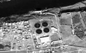
In a previous quarter imagery analysts provided aerial imagery of the Right Bank Drinking Water Treatment Plant that our assessment team relied upon for their Project Assessment report, as they were unable to visit the site due to security concerns. Highlighted below is aerial imagery of the Right Bank Drinking WTP in operation (SIGIR PA-07-106)
