Radar Ecology
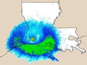
The nationwide network of Doppler weather radars is on the verge of revolutionizing
wildlife research and management. Determining the importance of landscapes
for migrant birds is difficult with ground-based surveys, but radar provides
an instantaneous, broad-scale, and quantitative measurement of bird abundance
in relation to landscape features. Researchers at the USGS National Wetlands
Research Center are using radar to study the habitat relations of spring and
fall migratory songbirds along the Louisiana and Texas coasts as well as movements
of wintering waterfowl between daytime resting sites and evening feeding sites.
NOTE: Some or all of the reports on this page are presented in Portable Document Format (PDF); the latest version of Adobe Reader or similar software is required to view them. Download the latest version of Adobe Reader, free of charge.
Research
Using Radar to Understand Migratory
Birds and Their Habitats: Critical Needs for the Gulf of Mexico
Migratory Bird Pathways and the
Gulf of Mexico
Advancing
Migratory Bird Conservation and Management by Using Radar: an Interagency
Collaboration
Biological
Applications of Radar Technologies: Migratory Birds
For more information, contact
Wylie Barrow
Lori Randall
Return to Forest Ecosystem

