The Department of City Planning proposes to amend the Zoning Map on all or portions of 530 blocks in South Jamaica and portions of adjacent communities, including St. Albans and Springfield Gardens in Queens Community District 12, to protect the lower-density character of these neighborhoods while allowing for a moderate increase in residential and commercial density along main corridors. A related application would extend the applicable area of the “Food Retail Expansion to Support Health” (FRESH) program to Community District 12’s commercial corridors.
The proposed actions are the result of close consultation with the “One Block At A Time” civic organization, the South Jamaica Steering Committee, Community Board 12, local elected officials and local community organizations. The proposal builds upon four previous neighborhood rezonings adjacent to the rezoning area adopted by the City Council: Springfield Gardens, 2005; Jamaica 2007; St. Albans, 2007; Laurelton, 2008.
The rezoning area encompasses South Jamaica and extends into portions of the Springfield Gardens and St. Albans communities, and is generally bounded by Liberty Avenue, 108th Avenue and South Road to the north; Merrick and Springfield Boulevards to the east; the North Conduit to the south; and the Van Wyck Expressway to the west.
Most of the buildings within the rezoning area consist of 1- and 2-family detached houses with small concentrations of 1- and 2-family semi-detached and attached houses. Over the last several years, South Jamaica and its neighboring communities have experienced development pressure largely due to its outdated zoning which has remained unchanged since 1961. The area’s existing R3-2 and R4 zoning districts allow a variety of housing types and densities that are inconsistent with the prevailing scale and built character of South Jamaica’s neighborhoods.
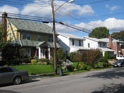
Single-family homes on Southgate Street south of 137th Avenue in an existing R3-2 district |
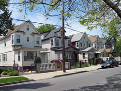
Single and two-family homes on Remington Street north of Shore Avenue in an existing R3-2 district |
The proposal consists of four components:
- Lower-density Contextual Rezoning: Zoning map amendment for all or portions of 528 blocks from R2, R3-2, R4, R5B, C8-1 and M1-1 districts to lower-density or lower density contextual zoning districts of R2, R3-1, R3-2, R3A, R3X, R4-1, and R4A to more closely reflect the existing lower density contexts.
- Medium-density Contextual Rezoning: Zoning map amendment for all or portions of 108 blocks from R3-2, R3A, R4, R4B and C8-1 districts to R5, R5B and R5D districts to reflect existing building and land use patterns and to allow for moderate-density increases along the area’s wide streets.
- Commercial Overlay Modifications: Zoning map amendment to either eliminate or reduce the depths of commercial overlays to prevent commercial intrusion onto residential blocks or to introduce commercial overlays to reflect current land uses and reinforce the character of the area’s wide streets.
- Zoning Text Amendment: Extend FRESH zoning incentives to commercially-zoned portions of Jamaica Avenue, Liberty Avenue, Hollis Avenue, Linden Boulevard, Farmers Boulevard, Baisley Boulevard, Rockaway Boulevard, Merrick Boulevard, and Guy R. Brewer Boulevard, as well as in C4-2 and M1-1 districts within CD 12.
|
 Items
accompanied by this symbol require the free
Adobe Acrobat Reader. Items
accompanied by this symbol require the free
Adobe Acrobat Reader.
|