Map
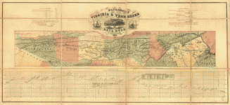
Map of Royal Land Company's railroad (narrow gauge) from their anthracite coal fields to deep water /

| Format |
Map |
|---|---|
| Contributors |
Braxton, Carter M. |
| Location |
United States Virginia |
| Language |
English |
| Subjects |
Mines And Mineral Resources Railroads Royal Land Company United States Virginia |
- Title
- Map of Royal Land Company's railroad (narrow gauge) from their anthracite coal fields to deep water /
- Description
-
Shows central Virginia from the Allegheny Mountains to the Chesapeake Bay.
-
Relief shown by form lines.
-
Pencil (some col.) on tracing paper, mounted on cloth.
-
LC Civil War maps (2nd ed.) H267
-
LC Railroad maps, 549
-
Available also through the Library of Congress Web site as a raster image.
-
1 map 49 x 108 cm.
- Creator
- Braxton, Carter M.
- Created Published
-
[187-]
- Subject Headings
-
-
Royal Land Company
-
-
Railroads--Virginia
-
-
Mines and mineral resources--Virginia
-
-
United States--Virginia.
- Notes
-
-
Shows central Virginia from the Allegheny Mountains to the Chesapeake Bay.
-
-
Relief shown by form lines.
-
-
Pencil (some col.) on tracing paper, mounted on cloth.
-
-
LC Civil War maps (2nd ed.) H267
-
-
LC Railroad maps, 549
-
-
Available also through the Library of Congress Web site as a raster image.
- Medium
-
1 map 49 x 108 cm.
- Call Number
-
G3881.P3 187- .B7
- Repository
-
Library of Congress Geography and Map Division Washington, D.C. 20540-4650 USA dcu
- Digital Id
-
g3881p rr005490 http://hdl.loc.gov/loc.gmd/g3881p.rr005490
- Library of Congress Catalog Number
- 98688793
Rights & Access
The maps in the Map Collections materials were either published prior to 1922, produced by the United States government, or both (see catalogue records that accompany each map for information regarding date of publication and source). The Library of Congress is providing access to these materials for educational and research purposes and is not aware of any U.S. copyright protection (see Title 17 of the United States Code) or any other restrictions in the Map Collection materials.
Note that the written permission of the copyright owners and/or other rights holders (such as publicity and/or privacy rights) is required for distribution, reproduction, or other use of protected items beyond that allowed by fair use or other statutory exemptions. Responsibility for making an independent legal assessment of an item and securing any necessary permissions ultimately rests with persons desiring to use the item.
More about Copyright and other Restrictions
For guidance about compiling full citations consult Citing Primary Sources.
Part of...
-
Hotchkiss Map Collection
[345]
-
Railroad Maps, 1828 1900
[617]
-
Transportation And Communication Cartographic Items
[761]
-
Civil War Maps
[2281]
-
Military Battles And Campaigns Cartographic Items
[3867]
-
Geography And Maps Division
[60803]
-
American Memory
[1120703]
More maps like this
-
 Profile, Royal Land Co. R.R. /
Contributor:
Braxton, Carter M.
Site:
American Memory-cultural, Main Catalog
Original Format:
Map
View catalog record
Profile, Royal Land Co. R.R. /
Contributor:
Braxton, Carter M.
Site:
American Memory-cultural, Main Catalog
Original Format:
Map
View catalog record
-
 [Map of Royal Land Company of Virginia lands in Rockingham, and Augusta counties Virginia, and Pendleton County, West Virginia] /
Contributor:
Oltmanns, C. W.
Site:
American Memory-cultural, Main Catalog
Original Format:
Map
Date:
1877
View catalog record
[Map of Royal Land Company of Virginia lands in Rockingham, and Augusta counties Virginia, and Pendleton County, West Virginia] /
Contributor:
Oltmanns, C. W.
Site:
American Memory-cultural, Main Catalog
Original Format:
Map
Date:
1877
View catalog record
-
 Map showing the economic minerals along the route of the Chesapeake & Ohio Rail Way to accompany the geological report of Thomas S. Ridgway.
Contributor:
Maury, Matthew Fontaine
Site:
American Memory-cultural, Main Catalog
Original Format:
Map
Date:
1872
View catalog record
Map showing the economic minerals along the route of the Chesapeake & Ohio Rail Way to accompany the geological report of Thomas S. Ridgway.
Contributor:
Maury, Matthew Fontaine
Site:
American Memory-cultural, Main Catalog
Original Format:
Map
Date:
1872
View catalog record
-
 Map showing the projected route of the Potomac and Ohio Railway.
Contributor:
G.W. & C.B. Colton & Co
Site:
American Memory-cultural, Main Catalog
Original Format:
Map
Date:
1874
View catalog record
Map showing the projected route of the Potomac and Ohio Railway.
Contributor:
G.W. & C.B. Colton & Co
Site:
American Memory-cultural, Main Catalog
Original Format:
Map
Date:
1874
View catalog record
-
 Map of the Springfield & Deep Run estates on the Coal Lands of the N. York & Richmond Coal Co, in Henrico Co. Virginia, their ...
Contributor:
DeBow, S. Herries
Site:
American Memory-cultural, Main Catalog
Original Format:
Map
Date:
1856
View catalog record
Map of the Springfield & Deep Run estates on the Coal Lands of the N. York & Richmond Coal Co, in Henrico Co. Virginia, their ...
Contributor:
DeBow, S. Herries
Site:
American Memory-cultural, Main Catalog
Original Format:
Map
Date:
1856
View catalog record
-
 A map of the Virginia Central Railroad, west of the Blue Ridge, and the preliminary surveys, with a profile of the grades.
Contributor:
Citti, L. F.
Site:
American Memory-cultural, Main Catalog
Original Format:
Map
Date:
1860
View catalog record
A map of the Virginia Central Railroad, west of the Blue Ridge, and the preliminary surveys, with a profile of the grades.
Contributor:
Citti, L. F.
Site:
American Memory-cultural, Main Catalog
Original Format:
Map
Date:
1860
View catalog record
-
 Map & profile of the Virginia & Tennessee Rail Road.
Contributor:
Blackford, W. W.
Site:
American Memory-cultural, Main Catalog
Original Format:
Map
Date:
1856
View catalog record
Map & profile of the Virginia & Tennessee Rail Road.
Contributor:
Blackford, W. W.
Site:
American Memory-cultural, Main Catalog
Original Format:
Map
Date:
1856
View catalog record
-
 Map showing locations of iron properties on and near Chesapeake and Ohio Railway, Virginia /
Contributor:
Hotchkiss, Jedediah
Site:
American Memory-cultural, Main Catalog
Original Format:
Map
Date:
1879
View catalog record
Map showing locations of iron properties on and near Chesapeake and Ohio Railway, Virginia /
Contributor:
Hotchkiss, Jedediah
Site:
American Memory-cultural, Main Catalog
Original Format:
Map
Date:
1879
View catalog record
-
 Map and profile of the Orange and Alexandria Rail Road with its Warrenton Branch and a portion of the Manasses [sic] Gap Rail Road, to ...
Contributor:
Faul, August
Site:
American Memory-cultural, Main Catalog
Original Format:
Map
Date:
1854
View catalog record
Map and profile of the Orange and Alexandria Rail Road with its Warrenton Branch and a portion of the Manasses [sic] Gap Rail Road, to ...
Contributor:
Faul, August
Site:
American Memory-cultural, Main Catalog
Original Format:
Map
Date:
1854
View catalog record
-
 [Map of mineral lands in Culpepper County, Virginia, on the Rapidan River].
Site:
American Memory-cultural, Main Catalog
Original Format:
Map
View catalog record
[Map of mineral lands in Culpepper County, Virginia, on the Rapidan River].
Site:
American Memory-cultural, Main Catalog
Original Format:
Map
View catalog record
-
 Experimental survey for the Eastern Shore Rail Road, Maryland, drawn by W. H. Emory & J. McClelland Asst. Civ. Engs., made under the direction of ...
Contributor:
Emory, William H.
Site:
American Memory-cultural, Main Catalog
Original Format:
Map
Date:
1853
View catalog record
Experimental survey for the Eastern Shore Rail Road, Maryland, drawn by W. H. Emory & J. McClelland Asst. Civ. Engs., made under the direction of ...
Contributor:
Emory, William H.
Site:
American Memory-cultural, Main Catalog
Original Format:
Map
Date:
1853
View catalog record
-
 Map showing the war operations, in Virginia & Maryland.
Contributor:
Bufford, John Henry
Site:
American Memory-cultural, Main Catalog
Original Format:
Map
Date:
1861
View catalog record
Map showing the war operations, in Virginia & Maryland.
Contributor:
Bufford, John Henry
Site:
American Memory-cultural, Main Catalog
Original Format:
Map
Date:
1861
View catalog record
-
 Map of eastern Virginia /
Contributor:
Nicholson, W. L.
Site:
American Memory-cultural, Main Catalog
Original Format:
Map
Date:
1862
View catalog record
Map of eastern Virginia /
Contributor:
Nicholson, W. L.
Site:
American Memory-cultural, Main Catalog
Original Format:
Map
Date:
1862
View catalog record
-
 Railroads in Virginia and part of North Carolina, drawn and engraved for Doggett's Railroad Guide & Gazetteer.
Contributor:
Doggett, John
Site:
American Memory-cultural, Main Catalog
Original Format:
Map
Date:
1848
View catalog record
Railroads in Virginia and part of North Carolina, drawn and engraved for Doggett's Railroad Guide & Gazetteer.
Contributor:
Doggett, John
Site:
American Memory-cultural, Main Catalog
Original Format:
Map
Date:
1848
View catalog record
-
 Map of the Virginia Central Rail Road showing the connection between tide water Virginia, and the Ohio River at Big Sandy, Guyandotte and Point Pleasant; ...
Contributor:
Vaisz, W.
Site:
American Memory-cultural, Main Catalog
Original Format:
Map
Date:
1852
View catalog record
Map of the Virginia Central Rail Road showing the connection between tide water Virginia, and the Ohio River at Big Sandy, Guyandotte and Point Pleasant; ...
Contributor:
Vaisz, W.
Site:
American Memory-cultural, Main Catalog
Original Format:
Map
Date:
1852
View catalog record
-
 Map showing the Fredericksburg & Gordonsville Rail Road of Virginia, leading from Fredericksburg, via Orange C.H., to Charlottesville, where it connects with the Chesapeake & ...
Contributor:
G.W. & C.B. Colton & Co
Site:
American Memory-cultural, Main Catalog
Original Format:
Map
Date:
1869
View catalog record
Map showing the Fredericksburg & Gordonsville Rail Road of Virginia, leading from Fredericksburg, via Orange C.H., to Charlottesville, where it connects with the Chesapeake & ...
Contributor:
G.W. & C.B. Colton & Co
Site:
American Memory-cultural, Main Catalog
Original Format:
Map
Date:
1869
View catalog record
You might also like
-

 Resources of south-west Virginia, showing the mineral deposits of iron, coal, zinc, copper and lead.
Contributor:
Boyd, Charles Rufus
Site:
Main Catalog
Original Format:
Book
Date:
1881
Resources of south-west Virginia, showing the mineral deposits of iron, coal, zinc, copper and lead.
Contributor:
Boyd, Charles Rufus
Site:
Main Catalog
Original Format:
Book
Date:
1881
-
 [Virginia. Tracks of the Orange & Alexandria Railroad, destroyed by the Confederates between Bristow Station and the Rappahannock]
Contributor:
O'Sullivan, Timothy H.
Site:
Prints & Photographs
Original Format:
Photo, Print, Drawing
Date:
1863
[Virginia. Tracks of the Orange & Alexandria Railroad, destroyed by the Confederates between Bristow Station and the Rappahannock]
Contributor:
O'Sullivan, Timothy H.
Site:
Prints & Photographs
Original Format:
Photo, Print, Drawing
Date:
1863
-
A study of the proposed Virginia Rail Transportation Development Authority /
Contributor:
Howe, Roger W.
Site:
Main Catalog
Original Format:
Book
Date:
2004
-
 Remains of wreck on the track, ready for transportation to Alexandria. This train was thrown from the track by the Rebels
Contributor:
Russell, Andrew J.
Site:
Prints & Photographs, Main Catalog
Original Format:
Photo, Print, Drawing
Date:
1861
View catalog record
Remains of wreck on the track, ready for transportation to Alexandria. This train was thrown from the track by the Rebels
Contributor:
Russell, Andrew J.
Site:
Prints & Photographs, Main Catalog
Original Format:
Photo, Print, Drawing
Date:
1861
View catalog record
-
 Engine "Government" [Commodore?] down the "banks" near Brandy, April 1864
Contributor:
Russell, Andrew J.
Site:
Prints & Photographs, Main Catalog
Original Format:
Photo, Print, Drawing
Date:
1864
View catalog record
Engine "Government" [Commodore?] down the "banks" near Brandy, April 1864
Contributor:
Russell, Andrew J.
Site:
Prints & Photographs, Main Catalog
Original Format:
Photo, Print, Drawing
Date:
1864
View catalog record
-
Status of the TransDominion Express passenger rail service : report of the Virginia Department of Rail and Public Transportation to the Governor and the General ...
Contributor:
Virginia. Dept. of Rail and Public Transportation
Site:
Main Catalog
Original Format:
Book
Date:
2005