![[December 18, 1944], HQ Twelfth Army Group situation map.](https://cybercemetery.unt.edu/archive/oilspill/20120921145649im_/http://www.loc.gov/collections/static/world-war-II-maps-military-situation-maps-from-1944-to-1945/images/ict21197.jpg)


![[Sketch of the battles of Chancellorsville, Salem Church, and Fredericksburg], May 2, 3, and 4, 1863](https://cybercemetery.unt.edu/archive/oilspill/20120921145649im_/http://www.loc.gov/collections/static/civil-war-maps/images/cwh00129.jpg)


![[January 1, 1945], HQ Twelfth Army Group situation map.](https://cybercemetery.unt.edu/archive/oilspill/20120921145649im_/http://www.loc.gov/collections/static/world-war-II-maps-military-situation-maps-from-1944-to-1945/images/ict21211.jpg)
![A map of the most inhabited part of New England... Thomas Jefferys, [London] Thos. Jefferys, 1755.](https://cybercemetery.unt.edu/archive/oilspill/20120921145649im_/http://www.loc.gov/collections/static/american-revolutionary-war-maps/images/ar079700.jpg)

![Boston its environs and harbour, with the rebels works raised against that town in 1775... Sir Thomas Hyde Page, [1775?].](https://cybercemetery.unt.edu/archive/oilspill/20120921145649im_/http://www.loc.gov/collections/static/american-revolutionary-war-maps/images/ct000070.jpg)
![[December 23, 1944], HQ Twelfth Army Group situation map.](https://cybercemetery.unt.edu/archive/oilspill/20120921145649im_/http://www.loc.gov/collections/static/world-war-II-maps-military-situation-maps-from-1944-to-1945/images/ict21202.jpg)

Results
-

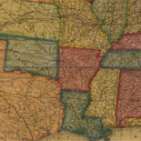
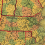
Bacon's military map of the United States shewing the forts & fortifications.
Scale ca. 1:8,000,000.
Contributor: Bacon and Company Site: American Memory-cultural - Main Catalog Original Format: Map Date: 1862 View catalog record -

Atlas of the war of the Rebellion giving Union and Confederate armies by actual surveys by the Union and Confederate engineers, and approved by the ...
Relief shown by contours, shading, and hachures on some maps.
Contributor: United States. War Dept Site: American Memory-cultural - Main Catalog Original Format: Map Date: 1892 View catalog record -
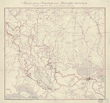
Map of a part of Louisiana and Mississippi : illustrating the operations of the U.S. Forces in the Department of the Gulf /
Covers the area west to east from Alexandria, La. to Pearl River, and north to south from Vidalia, La. to Atchafalaya Bay.
Contributor: United States Coast Survey Site: American Memory-cultural - Main Catalog Original Format: Map Date: 1863 View catalog record -

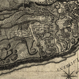
Map showing the location of battle fields of Virginia
Scale ca. 1:680,000.
Contributor: Chesapeake and Ohio Railway Company Site: American Memory-cultural - Main Catalog Original Format: Map Date: 1892 View catalog record -
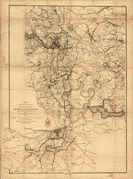
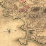
Region embraced in the operations of the armies against Richmond and Petersburg
Scale 1:80,000.
Contributor: United States. Army. Corps of Engineers Site: American Memory-cultural - Main Catalog Original Format: Map Date: 1865 View catalog record -

Diagram showing the position of the Sassacus and ram Albemarle at the time of collision.
Scale not given.
Contributor: United States. Navy Site: American Memory-cultural - Main Catalog Original Format: Map Date: 1864 View catalog record -

Extract of military map of N.E. Virginia showing forts and roads.
Covers Washington D.C. metropolitan area.
Contributor: United States. War Dept. Engineer Bureau Site: American Memory-cultural - Main Catalog Original Format: Map Date: 1865 View catalog record -

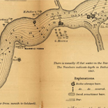
Upper Potomac from McCoy's Ferry to Conrad's Ferry and adjacent portions of Maryland and Virginia
Scale ca. 1:130,000.
Contributor: United States. Army. Corps of Engineers Site: American Memory-cultural - Main Catalog Original Format: Map Date: 1863 View catalog record -

Map showing the line of entrenchments of the Army N. Va. from Totopotomoy to the Chickahominy and the positions of the 2nd Corps, A.N.V. from ...
Shows Confederate troop positions and names of some residents.
Site: American Memory-cultural - Main Catalog Original Format: Map Date: 1864 View catalog record -

Second Manassas Campaign, August 17 - September 1, 1862 /
Relief shown by hachures.
Contributor: Russell, Robert E. L. Site: American Memory-cultural - Main Catalog Original Format: Map Date: 1862-09-01 View catalog record -
Map of n. eastern Virginia and vicinity of Washington /
Relief shown by hachures. Depths shown by soundings.
Contributor: United States. Corps of Topographical Engineers Site: American Memory-cultural - Main Catalog Original Format: Map Date: 1862 View catalog record -
Hill between hill no. 1 & Fort Meigs : [Washington D.C.].
Relief shown by contours.
Site: American Memory-cultural - Main Catalog Original Format: Map Date: 1860 View catalog record -

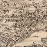
Encampment of U.St. troops at Newport News, Va., 1861 & 1862 /
Bird's eye view.
Contributor: E. Sachse & Co Site: American Memory-cultural - Main Catalog Original Format: Map Date: 1862 View catalog record -

[Western Virginia from Petersburg to Warm Springs, showing the movement of the Union army, 1862] /
Covers parts of the counties of Grant, Randolph, Pendleton, and Pocahontas, West Virginia and Highland and Bath, Virginia including the names of some residents.
Contributor: Hausmann, A. Site: American Memory-cultural - Main Catalog Original Format: Map Date: 1862 View catalog record -

Map of a part of the city of Richmond showing the burnt districts
Scale not given.
Contributor: Smith, William Ira Site: American Memory-cultural - Main Catalog Original Format: Map Date: 1865 View catalog record -

[Union troop positions north of Dallas, Georgia, May 25-June 5, 1864].
Shows Union troop positions in northeastern Paulding County, Georgia.
Site: American Memory-cultural - Main Catalog Original Format: Map Date: 1864-06-05 View catalog record -


Atlas of the American Civil War : national overview / Catalog Record - Electronic Resource Available
Relief shown by shading.
Contributor: Nelson, John Carl Site: Main Catalog Original Format: Map Date: 2010 -

Map illustrating the first epoch of the Atlanta Campaign : embracing the region from the Tennessee River to the Oostanaula River, showing the positions held ...
Scale ca. 1:80,000.
Contributor: Ruger, Edward Site: American Memory-cultural - Main Catalog Original Format: Map Date: 1974 View catalog record -

Map of the battlefield of Roanoke Id. Feb. 8th 1862
Scale ca. 1:1650 and 1:82,000.
Contributor: Andrews, William S. Site: American Memory-cultural - Main Catalog Original Format: Map Date: 1862 View catalog record -

[Map of Arkansas Post, Ark.] /
Relief shown by hachures.
Contributor: Pitzman, Julius Site: American Memory-cultural - Main Catalog Original Format: Map Date: 1863 View catalog record
Refine your search
Original Format
- Map
- Web Page [8]