
- Observing System Questions
- What is observing system design, simulation, and demonstration?
- Why are observing systems important?
- What are the benefits for society?
- What observing systems do we currently have in place?
- What are the data gaps?
- What new systems are needed?
- What is NOAA's role?
- Programmatic Information
- Theme Presentations
Observing System Design, Simulation, and Demonstration
Observing systems help us understand and predict the future of our environment.
Part of NOAA's mission is to understand and predict changes in the Earth's environment to meet the economic, social and environmental needs of our nation. Observing systems provide information required to make predictions ranging from short-term local weather forecasts to long-term global climate change. Design, simulation, and demonstration are used to optimize new observing systems and improve our predictive ability.
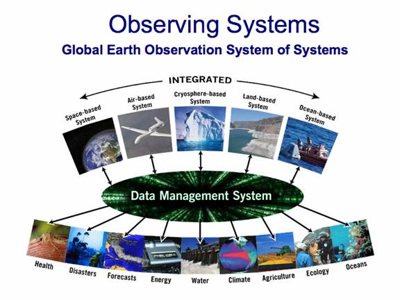
Figure 1 . The combination of acquiring the Earth-based data, managing it in an integrated approach, and analyzing the scientific questions for public policy makers is called Global Earth Observation Systems of Systems or GEOSS, a plan developed at NOAA.
What is Observing System Design, Simulation, and Demonstration?
Data collected by NOAA and its cooperative agencies and programs from space, airborne, cryosphere, land, and ocean systems are processed using models to make predictions (e.g. weather forecasts, ocean circulation changes), to simulate conditions, or to demonstrate their effects (e.g. climate change, energy use practices) for the future, present, or past. Because of the challenges posed with observing the environment, it is often necessary to test, evaluate, and compare different types of instruments to determine which one alone or in combination with others is best suited to meet a particular set of observational requirements.

Figure 2. ESRL recently conducted a year-long evaluation of current state-of-the-art wind profiling radar technology to determine which technology is best suited to measuring the coastal and marine environment. Information gained from this study will improve NOAA's integrated upper-air observing system.
Why are Observing Systems Important?
In order to forecast the weather using large, fast computers, it is necessary to have global observations of the present environmental state to feed into the programs to produce a forecast of the future environmental state. Observations are also used to improve understanding of the science of how the atmosphere and oceans behave, and to identify changes that are occurring in the environment. The goal is to put the best scientific data and its analysis in front of the decision makers in order to meet the daily agriculture, health, economic, energy, forecasting needs of society.
What are the Benefits for Society?
An improved observing system provides new and innovative ways to observe the environment. The benefits to society are to:
- Improve Weather Forecasting
- Reduce Loss of Life and Property from Disasters
- Protect and Monitor Our Ocean Resource
- Understand, Assess, Predict, Mitigate and Adapt to Climate Variability and Change
- Support Sustainable Agriculture and Forestry and Combat Land Degradation
- Understand the Effect of Environmental Factors on Human Health and Well- Being
- Develop the Capacity to Make Ecological Forecasts
- Protect and Monitor Water Resources
- Monitor and Manage Energy Resources
What Observing Systems do We Currently Have in Place?
The NOAA Observing Systems Architecture web site illustrates the existing observing systems. Some observing systems are designed for daily 'operational' weather forecasting, while others are designed to advance scientific knowledge of the environment. ESRL maintains an arsenal of instrumentation for use in global to regional research field studies devoted to improving our understanding of air quality, meteorology, hydrometeorology, carbon cycle, turbulence, air-sea interaction, climate, and the complex interaction between weather and climate. For example, the Global Monitoring Division has an extensive set of climate stations located worldwide for measuring trace gases, aerosols, and radiation at ground-based, shipboard, and airborne platforms.
The Meteorological Assimilation Data Ingest System (MADIS) developed by the Global Systems Division makes meteorological data from many different sources available to a wide range of users for improving weather and climate services. MADIS has the largest collection of surface meteorological data covering most of the world. Having this much data easily accessible by users makes it easier for researchers to enhance understanding of the atmosphere and how it affects our everyday lives.
What are the Data Gaps?
Observational gaps arise from an insufficient density of instruments, instruments that are not optimized to meet regional demands, and our desire to gain detailed knowledge of how the earth system works. The most notable data gaps occur in the polar regions, the oceans, central Africa, Asia, and South America. This is also a lack of routine vertical profiles of climate parameters (aerosols, trace gases, radiation) over the continental and oceanic regions of the world. The current observing system is not adequate for longer weather forecasts, whether these are monthly or seasonal. Even more importantly, the current observing network is not adequate for the evermore-important problem of analyzing, understanding, and forecasting climate on time scales from years to centuries. For this reason, it is important to pursue research projects aimed at improving our requisite knowledge.
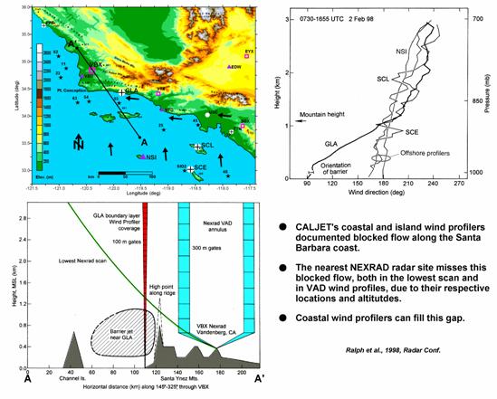
Figure 3. ESRL deployed wind profilers along the coast during the California Land-falling Jets Experiment that documented a gap in radars along the West Coast and provided operational weather forecasters with much needed wind data.
What New Systems are Needed ?
While these satellites have a stellar record in transforming the meteorological view of our planet, they still fall short in resolving the vertical structure of the atmosphere, which is important for weather forecasting and crucial for climate. In order to complement the global, large-scale picture and information from satellites, it is essential to put in place a network of high-resolution local observations of winds, temperature, water vapour, clouds, aerosols and gases.
ESRL scientists and NWS colleagues concluded that in the near future we will need:
- Detection, monitoring, and prediction of mesoscale phenomena over the continental U.S. and coastal zones
- Better observations of the boundary layer and the lower troposphere
- Moisture observations at sub-kilometer vertical resolution, especially within a few kilometers of the ground
- Frequent wind profiles
- Appropriately dense and frequent observations when and where a particular threat arises
ESRL, along with its partners, is working toward developing solutions for these challenges.


Figure 4. NASA Altair Unmanned Aircraft System (UAS) during NASA Fire Mission of 2006 (left) and Aerosonde during the NOAA Hurricane Demonstration of 2005 (right). UAS are a new technology which can be used to make observations in remote regions of the Earth. See the NOAA UAS Program for more information about the uses of UAS in environmental science.
What is NOAA's role?
NOAA is the nation's climate, and weather and water agency. Future changes in the environment could affect the other main goals of NOAA: Ecosystem Management, and Commerce and Transportation. NOAA had, has and will have a central role in developing and maintaining observing systems, both nationally, in the form of rawindsondes and weather radar, and globally, by being the major contributor of meteorological satellites, both polar orbiters and geostationary. New developments in observing systems could make people and economies healthier, safer, and better equipped to manage the daily needs and potential crisis. The aim is to make 21st century technology as interrelated as the planet it observes, predicts, and protects, providing the science on which sound policy and decision-making must be built.
Theme Presentations
- Overview (pdf)
- Observation System Simulation Experiments (OSSE) (pdf)
- NOAA and Unmanned Aircraft Systems (UAS) (5M pdf)
- Hydrometeorological Testbed (HMT) - The Empirical Approach to Observing System Design and Demonstration (4M pdf)