
NOAA Science Missions & Data
Deepwater Horizon/BP Oil Spill
“As the lead science agency for oil spill response, and as stewards of our oceans and coasts, NOAA is extremely concerned about the health of the Gulf of Mexico and the well-being of the millions of people who depend on these waters for their livelihoods and pleasure. The most important thing NOAA can do is bring the absolute best science to inform the ongoing response and recovery efforts.”
-Jane Lubchenco, NOAA Administrator
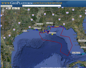
Screen shot from GeoPlatform.gov.
(Credit: NOAA)
GeoPlatform.gov is a one-stop shop for detailed near-real-time information and data about the response to the Deepwater Horizon/BP oil spill.
NOAA’s response has been immediate and sustained, strategic and scientific.
From day one, NOAA has been tracking every aspect of this spill: where the oil is going on the surface and under the sea, and what the consequences are to coastal communities, wildlife and the marine environment. We are bringing all scientific methods to this task:
- Satellites in space
- Planes in the air
- Boats on the water
- Gliders below the surface
- Scientists on the ground
NOAA Data Index
Seafood/Fisheries Monitoring Data [more]
Subsurface Oil Monitoring and Ocean Current Data
Data collected in the Gulf is being catalogued and posted on NOAA’s National Oceanographic Data Center.
Subsurface Oil Monitoring
-
Report by the Operational Science Advisory Team providing a summary and analysis of data from the subsurface monitoring program, including links to the datasets are available at: http://www.restorethegulf.gov/release/2010/12/16/data-analysis-and-findings
- Details on the systematic and comprehensive subsurface oil monitoring program NOAA is leading for the Unified Area Command may be found at RestoreTheGulf.gov
- Data from NOAA, and its federal and academic partners’ gulf science missions is being made available at NOAA’s National Oceanographic Data Center
Additional
- Analytical Chemistry Data from the R/V Brooks McCall
- Data Dictionary [xls]
- Brooks McCall Cruise 1- May 8, 2010 [xls] | Metadata [pdf]
- Brooks McCall Cruise 2 - May 15, 2010 [xls] | Metadata [pdf]
- Brooks McCall Cruise 3 - May 19, 2010 [xls] | Metadata [pdf]
- Brooks McCall Cruise 4 - May 23, 2010 [xls] | Metadata [pdf]
- Brooks McCall Cruise 5 - May 30, 2010 [xls] | Metadata [pdf]
See Joint Anaylsis Group section below for analysis of subsurface data
Ocean Currents
- Daily Ocean Conditions in the Gulf, AOML Mission Archives
- NOAA P3 Aircraft Loop Current Monitoring Flights XBTs data
- Temperature and Salinity Data from Nine Gliders
- Eleven Floats – Current location of floats and CTD data
- Center for Operational Oceanographic Products and Services (CO-OPPS)
- Tide and Current Information
- Integrated Ocean Observing System (IOOS)
- Historical Ocean and Current Data for Gulf of Mexico
- Daily surface oil trajectory map
Natural Resource Damage Assessment (NRDA) Data
As of Thursday, July 8, 2010, the Deepwater Horizon MC252 Resource Trustees agreed to publicly post NRDA 'Pre-assessment' science data once it is collected, analyzed, and properly quality checked, following the U.S. government's existing Information Quality Act. Releasing NRDA 'Pre-assessment' science data is rarely done in the NRDA process, but it was decided in the interest of transparency, and because of the heightened interest in this particular spill, that this information would be made public.
- Information Quality Act statement for NRDA collected data [pdf]
- Forensic Oil Sampling 1 - June 12 - 16, 2010 [xls] | Metadata [pdf] | Data Dictionary [pdf]
- Data Validation Reports [zip]
-
Gordon Gunter Cruse 1, May 28 - June 4, 2010 [xls] | Metadata [pdf] | Data Dictionary [pdf]
- Jack Fitz
- Cruise 1 - May 10, 2010 [xls] | Metadata [pdf] | Data Dictionary [pdf]
- Data Validation Reports [zip]
- Cruise 2 - May 21 - 31, 2010 [xls] | Metadata [pdf] | Data Dictionary [pdf]
- Cruise 3 - Sept. 28 - present [xls] | Metadata [pdf] | Data Dictionary [xls]
- Cruise 1 - May 10, 2010 [xls] | Metadata [pdf] | Data Dictionary [pdf]
- Brooks McCall
- Cruise 2 - May 17, 2010 [xls] | Metadata [pdf] Data Dictionary [pdf]
- Cruise 3 - May 21, 2010 [xls] | Metadata [pdf] Data Dictionary [pdf]
- Cruise 4 - May 23-25, 2010 [xls] | Metadata [pdf] Data Dictionary [pdf]
- Cruise 5 - May 30 - June 1, 2010 [xls] | Metadata [pdf] Data Dictionary [pdf]
- Cruise 6 - June 5-7, 2010 [xls] | Metadata [pdf] | Data Dictionary [pdf]
- Data Validation Reports [zip]
- Cruise 9 - June 22-26, 2010 [xls] | Metadata [pdf] | Data Dictionary [pdf]
- Data Validation Reports [zip]
- Endeavor
- Cruise 1 - June 17 -28, 2010 [xls] | Metadata [pdf] | Data Dictionary [pdf]
- Data Validation Reports [zip]
- Cruise 1 - June 17 -28, 2010 [xls] | Metadata [pdf] | Data Dictionary [pdf]
- Ocean Veritas
- Cruise 1 - May 27-29, 2010 [xls] | Metadata [pdf] | Data Dictionary [pdf]
- Cruise 4 - June 13-17, 2010 [xls] | Metadata [pdf] | Data Dictionary [pdf]
- Data Validation Reports [zip]
- Cruise 5 - June 19-23, 2010 [xls] | Metadata [pdf] | Data Dictionary [pdf]
- Data Validation Reports [zip]
Air Quality Data
Satellite Data and Imagery
- Satellite Data: Deepwater Horizon Support
- NOAA Remote Sensing Division imagery of the Gulf Coast following the Deepwater Horizon Incident
- Oil Spill Imagery
- Satellite Derived Surface Oil Analysis Products
- NOAA Satellite and Information Service products and operations involved in response to Gulf of Mexico oil spill
- Daily SST Climatologies
- Ocean Surface Topography
Inter-Agency Joint Analysis Group (JAG)
This interagency panel, comprised of scientists from NOAA, EPA, and the White House Office of Science and Technology Policy, was created to coordinate information about subsurface sampling related to the Deepwater Horizon/BP oil spill.
Administration’s Joint Analysis Group Releases First Scientific Report on Subsea Monitoring data from Gulf Spill – A peer-reviewed, inter-agency report about Brooks McCall subsurface monitoring near the Deepwater Horizon wellhead, May 8-25, released on June 23. Full Report [PDF]; News Release
Second Federal Analysis Gives Further Clues about Location and Movement of Subsurface Oil - A peer-reviewed, inter-agency report about subsurface monitoring near the Deepwater Horizon wellhead based on data collected by the R/V Brooks McCall, R/V Ocean Veritas, R/V Walton Smith, NOAA Ship Thomas Jefferson and NOAA Ship Gordon Gunter, May 19-June 19, released on July 23. Full Report [PDF]; News Release
Data Supplement to Joint Analysis Group Report 2 - The Joint Analysis Group Report 2 published on July 23, 2010 reported on data collected between May 19 and June 19, 2010. This supplement extends those data to July 13, 2010. The figures in this supplement should be interpreted in the context of the July 23, 2010 report. Supplement Report [PDF]
Instrument drift check procedures for CDOM Fluorometers at the Deepwater Horizon Site - This quick-response, time sensitive data report presents guidance for at sea operations. The report contains the JAG recommendation for best practices for checks against instrument drift for WetLabs Eco CDOM Instruments. Full Report [PDF]
Initial Quality Control of Analytical Chemistry Data - This report describes the initial quality control of analytical chemistry reported for samples collected by the R/V Brooks McCall through station 117 and the R/V Ocean Veritas through station 105, including the analytical data. Full Report [PDF]
Third Federal Analysis Examines Dissolved Oxygen Concentrations Near Wellhead - This peer-reviewed, interagency report presents a comprehensive examination of preliminary data on dissolved oxygen concentrations near the site of the BP Deepwater Horizon incident. Data were collected by the NOAA Ship Gordon Gunter, NOAA Ship Henry Bigelow, NOAA Ship Nancy Foster, NOAA Ship Thomas Jefferson, R/V Brooks McCall, R/V Ferrel, R/V Jack Fitz, R/V Ocean Veritas, and R/V Walton Smith, May 8-Aug. 9, released on Sept. 7. Full Report [PDF]. News Release.
Deepwater Horizon Oil Budget Calculator Technical Documentation
November 23, 2010 - The Federal Interagency Solutions Group, established at the request of the U.S. Coast Guard and authorized under a directive from the National Incident Commander (NIC), released a peer-reviewed report that details the scientific calculations of the Deepwater Horizon BP Oil Spill “Oil Budget Calculator” response tool announced in August.
- Download full report from RestoretheGulf.gov [pdf]
- Press Release (November 23, 2010)
Federal Interagency Group Issues Peer-Reviewed 'Oil Budget' Technical Documentation - Press Release (August 4, 2010)
Federal Science Report Details Fate of Oil from BP Spill
NOAA Science Missions
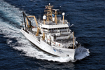
NOAA Ships

(Credit: NOAA)
Mission 1 (July 29 - Aug. 21, 2010)
NOAA Ship Henry B. Bigelow is supporting the Deepwater Horizon/BP wellhead integrity monitoring effort using its sophisticated acoustic echo-sounders to monitor for oil and gas releases the vicinity.
(Credit: NOAA)
Mission 1 (June 2 - July 2, 2010)
Surveying reef fish, bottom-dwelling fish, and shrimp in the eastern and western Gulf of Mexico to sample for seafood and water quality and species abundance as part of the oil spill response.
Links
Press Release: Missouri Teacher Sails in Gulf of Mexico Aboard NOAA Ship Pisces
Press Release: Alabama Teacher Sails in Gulf of Mexico Aboard NOAA Ship Pisces
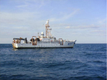
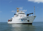
Mission 2 (July 14 - Sept. 3)
NOAA Ship Pisces supported the BP Deepwater Horizon wellhead integrity testing effort. The 209-ft. ship used sophisticated echo-sounders to monitor for oil and gas releases in the immediate vicinity of, and directly over, the well head. Data from the mission are being analyzed by the National Incident Command, NOAA and the University of New Hampshire.
Mission 3 (Sept. 9 - Sept. 17)
NOAA Ship Pisces, with a team of scientists from Texas A&M University and the University of California at Santa Barbara on board, collected water samples, checked the temperature and salinity at selected spots in the Gulf of Mexico, and measured the dissolved oxygen in the water.
Mission 4 (Sept. 24 - Oct. 4)
NOAA Ship Pisces is underway with a team of federal and academic scientists on a mission to collect water and sediment samples focusing within 25 miles of the BP Deepwater Horizon wellhead. The mission is part of the ongoing subsurface oil monitoring efforts being carried out by the Unified Area Command to track the fate of oil from the spill in the deep water of the Gulf.

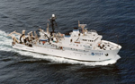
(Credit: NOAA)
Mission 1 (June 26-Aug. 22, 2010)
Surveying reef fish, bottom-dwelling fish, and shrimp in the eastern and western Gulf of Mexico to sample for seafood and water quality and species abundance as part of the oil spill response.
Links
Press Release: Mississippi Teacher Sails In Gulf of Mexico Aboard NOAA Ship Oregon II

(Credit: NOAA)
Mission 1 (June 29-July 18, 2010)
To better understand the loop current and how it may change over time, as well as to sample planktonic animals potentially affected by the spill. .
Links
Press Release: NOAA Sends Two Ships to Study Loop Current and Coastal Florida Waters
Mission Report: NOAA Ship Nancy Foster Mission Report
Mission 2 (July 21-Aug. 8, 2010)
NOAA Ship Nancy Foster is using a remotely operated vehicle to monitor deep-water bottom habitats that have been exposed to the oil/dispersant mixtures from the Deepwater Horizon/BP incident, investigating what impacts may have occurred at this stage of the spill. Researchers will visit areas in the northern Gulf of Mexico that have been previously sampled as well as go to new areas to collect baseline samples on deep-water corals and associated marine life in the Gulf.
Mission 3 (Aug. 13-23, 2010)
NOAA Ship Nancy Foster will collect data to support an assessment of the ecological condition of coastal-ocean waters along the U.S. continental shelf in the Gulf of Mexico. The effort will complement previous baseline surveys of shelf waters along the U.S. West Coast, mid-Atlantic and South Atlantic coasts, and portions of Florida. Data from the mission will help researchers evaluate potential environmental impacts from the Deepwater Horizon oil spill.
(Credit: NOAA)
Mission 1 (June 26 - July 24, 2010)
To collect tunas, swordfish and sharks to gather data about the conditions these highly migratory species are experiencing in waters around the Gulf of Mexico spill site.
Links
Press Release: NOAA Ship Delaware II to Collect Tunas, Swordfish, Water Samples on Deepwater Horizon Spill Study
(Credit: NOAA)
Mission 1 (May 27 - June 4, 2010)
Researchers took water samples and tested advanced methods for detecting submerged oil. They also conducted plankton tows and surveys of fish larvae.
Partners
University of New Hampshire, the Monterey Bay Aquarium Research Institute, University of South Florida, U.S. Coast Guard, U.S. Environmental Protection Agency
Links
Press Release: NOAA Research Ship Gordon Gunter Expands Gulf Mission
Mission Report: NOAA Ship Gordon Gunter Mission Summary [PDF]
Report: MBARI AUV Preliminary data report [PDF]
Mission 2 (June 14 - July 30, 2010)
NOAA Ship Gordon Gunter studied sperm whales and other marine mammals to learn more about how they are affected by the oil spill. It will be tracking their abundance and distribution both with visual surveys and by recording sounds using an array of underwater microphones. The ship also monitored for the presence of oil and gas near the wellhead as part of the Unified Command's wellhead integrity testing.
Links
Press Release: NOAA and University Scientists Launch Research Cruise to Determine Effects of Oil Spill on Endangered Whales
Mission 3 (Aug. 2 - Aug. 8, 2010)
NOAA Ship Gordon Gunter conducted water chemistry studies in the vicinity of the wellhead.
Partners
Cooperative Institute for Marine and Atmospheric Studies (University of Miami)
(Credit: NOAA)
Mission 1 (June 3 - 11, 2010)
Researchers took water samples and tested advanced methods for detecting submerged oil while gathering oceanographic data in the area’s coastal waters.
Partners
University of New Hampshire Center for Coastal and Ocean Mapping, Woods Hole Oceanographic Institution
Links
Press release: Initial Observations from the NOAA Ship Thomas Jefferson
Mission Report: NOAA Ship Thomas Jefferson Deepwater Horizon Response Mission Report- 6/11/2010[PDF]
Mission 2 (June 15 -July 2, 2010)
Researchers used sophisticated acoustic and water chemistry monitoring instruments to detect and map submerged oil in coastal areas and in the deep water surrounding the BP wellhead. The ship also took water chemistry measurements and samples in the vicinity of Flower Garden Banks National Marine Sanctuary, and collected air samples in the areas around the wellhead and downwind of the spill site.
Partners
NOAA-University of New Hampshire Joint Hydrographic Center
Links
Press Release: NOAA Ship Thomas Jefferson Continues Deepwater Horizon Spill Study Mission
Mission Summary: NOAA Ship Thomas Jefferson Deepwater Horizon Response Mission Summary - 7/2/2010 [PDF]
Mission Report: NOAA Ship Thomas Jefferson Deepwater Horizon Response Mission Report Interim Project Report-Leg 3, June 15-July 1, 2010 [PDF]
Non-NOAA Ships
Ocean Ecology
Seward Johnson
In the eastern Gulf of Mexico to gather baseline data against which to measure change if oil from the Deepwater Horizon/BP spill reaches the area.Partners
This mission is funded by NOAA’s Cooperative Institute for Ocean Exploration, Research and Technology and is led by Florida Atlantic University’s Harbor Branch Oceanographic Institute and the University of North Carolina, Wilmington. Other partners include SRI International in St. Petersburg, Fla., and the University of Miami.Links
Press Release: NOAA, U.S., Brazilian Partners Send Ship to Study Corals, Water Column for Gulf Oil Spill Response
Seafood Safety Sampling
Beau Rivage
In the closed fishing zone in the eastern Gulf, using bottom longline gear to catch fish for seafood safety samples.
Gandy
Conducting a vertical line survey in the eastern Gulf, collecting seafood safety samples.
Caretta
Trawling and plankton work in the oiled area off Mississippi, collecting seafood safety samples.
Subsurface Oil Detection
Pelican
Mission 1 (May 2 - 16, 2010)
Bottom sediment sampling and water column work. Water sampling, new sensors including a Wetlabs fluorometer intended to detect oil at depth.Partners
Owned by Louisiana Universities Marine Consortium
Mission 2 (May 16 - 24, 2010)
Examining hydrographic, chemical and biological properties and taking water and sediment samples for analysis of oil content.
Partners
Dr. Nancy Rabalais of the NOAA-supported Louisiana Universities Marine Consortium
Weatherbird II
Mission (May 22 - 28, 2010)
Mission conducting sampling to determine presence, concentration and location of subsurface oil.Partners
University of South FloridaLinks
Press release: NOAA Completes Initial Analysis of Weatherbird II Water Samples
NOAA Aircraft:
These NOAA Aircraft have been part of the Deepwater Horizon Response

(Credit: NOAA)
N42RF Orion (WP-3-D)
Mission Description
One of NOAA’s WP-3D aircraft flew regular research missions to learn more about the Gulf of Mexico Loop Current. Sensors dropped from the plane into the ocean measured temperature and salinity to help scientists track the movement of the Loop Current. This information helps responders and officials in coastal areas all around the Gulf to better understand the likelihood of shoreline impacts.
Partners
University of Miami Rosenstiel School of Marine and Atmospheric Research
Links
Mission Data
N43RF Orion (WP-3D)
Mission Description
NOAA WP-3D Orion aircraft deployed to the Gulf to help monitor air quality near the Deepwater Horizon/BP Oil Spill.
Links
Press release: NOAA Deploys Additional High Powered Research Aircraft to Gulf to Help Monitor Air Quality
Mission Report: Air Chemistry in the Gulf of Mexico Oil Spill Area NOAA WP-3D Airborne Chemical Laboratory Flights of 8 and 10 June 2010
N46RF Twin Otter (DHC-6)
Mission Description
Marine mammal surveys, multispectral scanning/oil density-thickness.

(Credit: NOAA)
N56RF Twin Otter (DHC-6)
Mission Description
Marine mammal surveys
N57RF Twin Otter (DHC-6)
Mission Description
Marine mammal surveys
N68RF King Air (BE-350ER)
Mission Description
Coastal photography/mapping
NOAA’s fleet of ships and aircraft is operated by the NOAA Office of Marine and Aviation Operations.
Science Meetings
May 27, 2010 – UNH Coastal Response Research Center, NOAA, EPA and Coast Guard Convene Science Meeting to Study Dispersant Use and Ecosystem Impacts of Dispersed Oil in the Gulf of Mexico.
June 3, 2010 – Gulf Oil Spill Scientific Symposium
The Deepwater Horizon/BP oil spill is having significant ecological impacts on the Gulf of Mexico and coastal states in the region. As the nation responds to this unprecedented spill, non-federal scientists can play a major role in the efforts to understand and combat the impacts of this spill. The Consortium for Ocean Leadership is hosting this symposium to identify for the federal agencies the existing gaps in the scientific knowledge; opportunities to fill those gaps; and priorities for short- and long-term research needs to understand the impact of the spill on the Gulf ecosystems and human health. Ocean Leadership is working with NOAA and other government organizations as partners of this event.
July 1-2, 2010 – Oil Spill Response Workshop, hosted by NOAA’s Atlantic Oceanographic and Meteorological Laboratory was held in Miami on July 1-2, 2010.
Published Papers
Aug. 18: Simulations of Underwater Plumes of Dissolved Oil in the Gulf of Mexico -- Geophysical Research Letters. A team of scientists from GFDL and NOAA's Office of Response and Recovery used a high-resolution global ocean climate model and take into account the microbial oxidation of oil to explore the probable extent of toxic concentrations of dissolved oil and of significant deep (1000-1300 m) oxygen depletion arising from the Deepwater Horizon spill.
Subsurface Sampling Maps for September 30 Press Conference
- Ongoing and Planned Sampling Locations: 9/29/10 (pdf)
- Sampling Locations Within the Last Week: 9/29/10 (pdf)