Guided Hikes, Winter and Spring 2012
Trackways National Monument Video (KRWG News)
Trackways National Monument Information Flyer (pdf)
PTNM, The Monument in Your Backyard (presentation)
Traces of a Permian Seacoast Booklet (14 MB)
The Prehistoric Trackways National Monument was established in 2009 to conserve, protect, and enhance the unique and nationally important paleontological, scientific, educational, scenic, and recreational resources and values of the Robledo Mountains in southern New Mexico. The Monument includes a major deposit of Paleozoic Era fossilized footprint megatrackways within approximately 5,280 acres.
The trackways contain footprints of numerous amphibians, reptiles, and insects (including previously unknown species), plants, and petrified wood dating back 280 million years, which collectively provide new opportunities to understand animal behaviors and environments from a time predating dinosaurs. The site contains the most scientifically significant Early Permian track sites in the world.
There are opportunities for hiking, horseback riding, and off highway vehicle driving in portions of the monument. However, viewing trackways is limited; as they are discovered, and to preserve them for ongoing and future scientific study, the trackways are removed and transported to the New Mexico Museum of Natural History and Science. Anyone interested in viewing these fascinating tracks can do so by visiting the Museum, which offers public tours of their Geoscience Collection, including the Trackways Collection, by reservation.
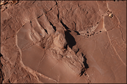
The Prehistoric Trackways National Monument is located at an elevation of about 4,500 feet above sea level in the Robledo Mountains north of Las Cruces. This is a desert area in a series of canyons cut into the steep mountains, dominated by creosote. Rainfall averages 8.5 inches annually, with most coming during July, August, and September. Thunderstorms are a common occurrence and lightning poses a hazard to hikers. Average temperatures range from highs in the 90's to lows in the 20's. In warmer weather rattlesnakes are sometimes sighted in the canyons or heard under rocks so please be alert.
Location / Access | Location Map
BLM is developing plans to facilitate public access to the National Monument. There are currently no facilities or signs for or at the Monument. This website will provide updates about public access as they become available.
The New Mexico Museum of Natural History is located at 1801 Mountain Road NW in Albuquerque. From Interstate 40, take Rio Grande Boulevard south about half a mile to Mountain Road, then east on Mountain Road less than a half a mile to the Museum, turning north on 18th street to the parking lot. The Museum entrance is on 18th Street.
Directions
Coming from the North (I-25): At the Dona Ana Exit: From NM320 (Thorpe Road) in Doña Ana, go west to US 85, then go north about a half a mile to Shalem Colony Road. Turn west on Shalem Colony Trail, which curves to the south. Go about 1.5 miles until you cross over the Rio Grande then take a right onto county road, Rocky Acres Trail. After turning on Rocky Acres Trail go approximately ¼ mile and then turn left onto the only dirt road leading to the west. Cross over a cattleguard and continue to the west. This road, past about a mile, is for high-clearance, 4wd vehicles only.
Coming from the South (Las Cruces): Travel on Picacho Ave./ Hwy. 70, at the stop light with Shalem Colony Trail, go north on Shalem Colony Trail for approximately 5.5 miles. Prior to reaching the Rio Grande River, you will reach a county road, Rocky Acres Trail. Turn west on Rocky Acres Trail. Go west approximately ¼ mile to a dirt road entrance on the left-hand side. Cross over a cattleguard and continue to the west. This road, past about a mile, is for high-clearance, 4wd vehicles only.